2.4. The Pilot Project “Cleaning Bottom Sediments of Kola Bay from Hazardous Substances. Phase 1. Monitoring Hazardous Substances in KolaBay Bottom Sediments
The Project Goal was to monitor Kola Bay muddy grounds to identify the extent of their contamination from man-induced impacts, with the monitoring findings to serve as information framework for the development of a technical project for pollution abatement of Kola Bay and cleaning it up from highly contaminated bottom sediments.
The Project was implemented by the non-for-profit organization “Harmonious Development Ecological Foundation (EFGR)”.
The Project duration 15 November 2007 - 15 March 2008
The Project Activities
- Environmental monitoring was carried out. Acoustic equipment was used to conduct reconnaissance study of spatial distribution of bottom sediments in the southern part of Kola Bay. Seismic acoustic equipment was used to determine muddy bottom sediments distribution. Arial survey grounds were selected. Acoustical equipment was used to carry out arial survey. Distribution and thickness of muddy grounds were determined. Bottom samplers and samplers took bottom sediment samples at the corners and in the center of the selected arial survey grounds. The bottom sediment core samples were analyzed and the ground composition was determined.
- Analytical studies and their interpretations were done. A laboratory analyzed the bottom sediment samples for contamination with heavy metals, petroleum hydrocarbons (n-paraffins, PAH), chlorine organic pesticides and PCBs, with the follow up interpretation of the laboratory essays.
- A concluding Project meeting was held with representatives of federal executive authorities, regional authorities, and other stakeholders to discuss the outcomes of this Pilot Project and to prepare a technical project for pollution abatement of Kola Bay and cleaning it up from highly contaminated bottom sediments.
The Project Outcomes
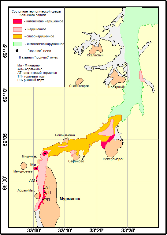
Figure 9. Geoenvironmental Map of Kola Bay was Made on the Basis of Monitoring
-
Because of the combined load of man-induced impacts on the marine environment, Kola Bay faces the highest loads in the Russian Arctic. At the same time, it is till a Category I fisheries water body.
-
The main sources of pollution of Kola Bat, in particular of its southern and middle parts, include industrial enterprises, municipal wastewater discharges, and operations of the civil and military fleets. Untreated discharges account for 78% of wastewater. There is an urgent need to put into operation wastewater treatment facilities in Murmansk.
-
Conducted in recent years, the GU MURMS monitoring showed that the quality of the Bay waters was characterized as “moderately polluted” – “polluted” in its southern part, as “moderately polluted” in its central part, and as “moderately polluted” in its northern part.
-
In some parts of the Bay, marine water demonstrates consistently high concentrations of biogenic elements, suspended solids and organic substances (for instance, at the water station near theCommercial Port).
-
Oil pollution of water (oily films, dissolved oil products) is constantly observed in the Bay waters. Vessels and ships keep on discharging bilge and oily water without permits. There has been no cleaning up of the bay from oil pollution in recent years. Visible during the low tide, the wide oily strip on the steep shores is a pronounced indicator of the overall pollution of the bay surface. There is an urgent need to renew regular collection of oily patches from the bay surface and to implement measures for the prevention of unauthorized discharges of oil products into the bay waters.
-
Bottom sediments accumulate oil products. The threat of continued increase in the oil pollution of water and bottom sediments in Kola Bay is associated with the forecasted increase in the scope and scale of oil products carriage and overhaul through Kola Bay.
-
Illegal shipwreck dump sites are hotbeds of high environmental risks, a significant source of polluting water and bottom sediment with oil products, heavy metals and persistent organic pollutants. In some cases the dump sites represent a serious navigational hazard. The shipwreck dump sites limit the economic use of coastal areas (i.e. development of coastal fisheries, revival of coastal communities, aquaculture farming, etc.).
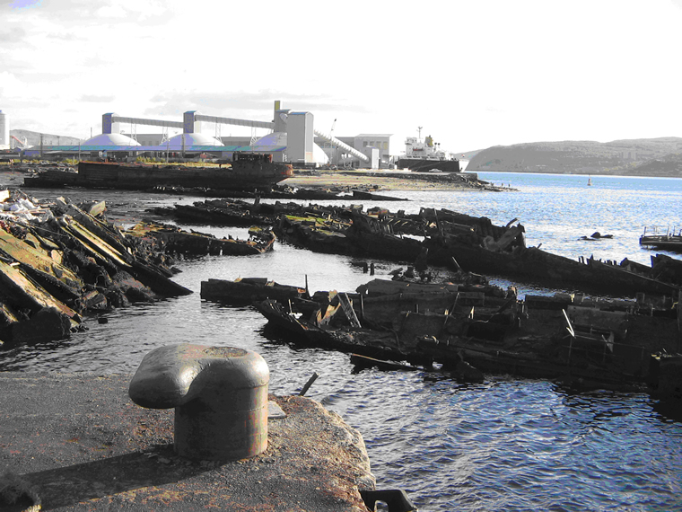
Figure 10. Unauthorized Salvage Shipyard as Environmental Hotspot -
High concentrations of pollutants in bottom sediments of the bay are, in turn, a source of secondary water pollution causing dramatic deterioration of the entire bay ecosystem.
-
Based on the analysis of pollutants in the sediments of the southern bend of Kola Bay and on the substantial percentage of pollutants in the mud water one can conclude that the negative trend will continue or even escalate.
-
Contamination of some coastal sections of the Kola Bay bed (the ports water areas, shipyards, the Northern Navy bases, shipwreck dump sites, etc.) has reached such concentrations that it is time to develop a special cleanup project.
-
The 2007 monitoring studies showed that it was necessary to dredge and dispose of not only the highly contaminated silty soil sediments but also sand sediments (at the study planning stage it was assumed that the sea currents washed out from the latter most pollutants and the highest percentage of pollutants was expected to be only found in silty soils).
-
The environmental state of the bay is such that it could barely cope with pollution through the bay’s natural self-purifying capacity (currents, tides, river runoff). If this capacity is overstretched, an ever increasing load may lead to the establishment of areas of environmental hazard. In this context, it is of particular importance to start developing the Kola Bay Integrated Coastal Zone Management Program (ICZMP) covering all the aspects of natural resources management and environmental protection in the bay.
-
As it is, Kola Bay is a "hot spot" for the entire Barents region, and the geological conditions - it is located in the actual seismic zone - increase many times the risks of technological hazards.
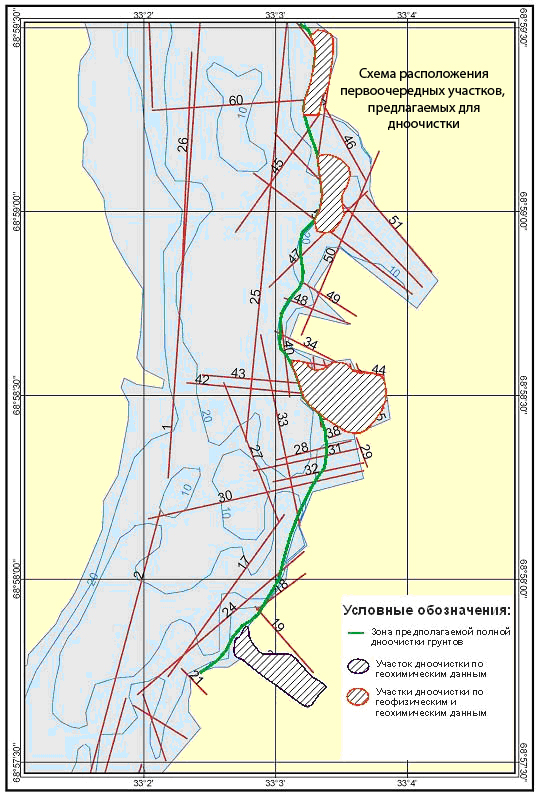
Figure 11. Layout of Seafloor Areas for Priority Cleanup
The Concept of the Technical Project on Pollution Abatement in Kola Bay and Cleanup of Kola Bay from Highly Polluted Sediments was proposed based on the results of the Pilot Project. It features the following components:
The project for cleaning up the southern bend of Kola Bay from heavily contaminated sediments should be developed with the aim of reducing secondary contamination of the bay waters and, accordingly, of reducing export of pollutants into the Barents Sea.
The project should include not only the organizational and technical activities related to dredging the sediments, but also a set of activities for the disposal of dredged soils.
When developing the Kola Bay bed cleanup project, care must be taken to consider the following main aspects:
- Assessing the hazard class of soils to be dredged;
- Dewatering the dredged soils on the temporary storage sites;
- Methods of recycling or burial of the dredged soils depending on the content of the most hazardous pollutants;
The Kola Bay bed should be cleaned from heavily contaminated sediments within the projected boundaries by using a pipeline dredger or chain-and-bucket dredger. The slurry should be transported in a barge or through a slurry pipeline to a temporary storage site for dewatering and waste water clarification.
Given the volume of the contaminated bottom soil to be removed, the cleanup works should be carried out in sequences. The performance of each sequence can be based on the design capacity of the depositing sites, boundaries of the work sites, and the dredger operation schedule as agreed upon with its owner.
Temporary dump sites for the contaminated slurry could be located in coastal areas in the near vicinity to Kola Bay. Given the amount of the proposed work, the size of the water area, the navigation-related limitations, and other factors, several land plots for slurry dump sites should be allocated. Optimally, the sites should be located at approximately equal distances from each other, in accordance with the design distance for the transportation of slurry to the point of discharge for a specific dredge. Otherwise it would be necessary to include additional costs of physical and technical resources for the organization of the booster stations, barges, movements of a hopper dredger, etc.
The project must provide for diving or instrumentation (for instance, sonar) survey of the bay bed to identify underwater obstacles and the size of sunken matters. Just before dredging, works should be carried out to remove the identified large items (sized more than 1 m in any dimension) from the bay bed.
The Project should have a separate section to review and study a sediment dredging technology in the shipwreck dump locations. The Project should design and propose a technology for cleaning Kola Bay from sunk vessels and ships/vessels abandoned at drying. In each case, the technology of cleaning the bay from vessels must be determined taking into account the specific conditions:
- The location of the vessel (the distance from the shore, depth);
- Availability of sites to arrange the technological process for the initial disposal works;
- Vessels lifting and disposal methods;
The project should provide for modern methods of cutting vessels underwater into large sections, as well as methods to reduce the pollution of the surrounding waters during the salvage operations.
| « Previous | Next » |